Mount St. Helens
 At
8:32 Sunday morning, May 18, 1980, Mount St. Helens erupted. At
8:32 Sunday morning, May 18, 1980, Mount St. Helens erupted.
Shaken by an earthquake measuring 5.1 on the Richter scale, the north
face of this tall symmetrical mountain collapsed in a massive rock
debris avalanche. In a few moments this slab of rock and ice slammed
into Spirit Lake, crossed a ridge 1,300 feet high, and roared 14 miles
down the Toutle River.
The avalanche rapidly released pressurized gases within the volcano. A
tremendous lateral explosion ripped through the avalanche and developed
into a turbulent, stone-filled wind that swept over ridges and toppled
trees. Nearly 150 square miles of forest was blown over or left dead and
standing.
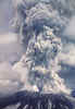
At the same time a mushroom-shaped column
of ash rose thousands of feet skyward and drifted downwind, turning day
into night as dark, gray ash fell over eastern Washington and beyond.
Wet, cement-like slurries of rock and mud scoured all sides of the
volcano. Searing flows of pumice poured from the crater. The eruption
lasted 9 hours, but Mount St. Helens and the surrounding landscape were
dramatically changed within moments.
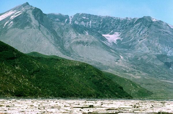
A vast, gray landscape lay where once the forested slopes of Mount St.
Helens grew. In 1982 the In 1982 President Reagan and Congress created
the 110,000-acre Mount St. Helens National Volcanic Monument for
research, recreation, and education. Inside the Monument, the
environment is left to recover naturally from the eruption.
Click
to return to Mt. St. Helens Volcanic Handblown Glass Ornaments.
Scientists and visitors follow the changes in the
landscape and the volcano. Surviving plants and animals rise out of the
ash, colonizing plants catch hold of the earth, birds and animals find a
niche in a different forest on the slopes of Mount St. Helens.
The volcano continued to erupt until 1986, violently at first, then
quietly building a lava dome. Thick pasty lava eruptions oozed out, each
one piling on top of the next, like pancakes in a sloppy pile. The lava
dome is now 920 feet high. The United
States Geological Survey scientists continue to monitor the volcano
for earthquakes, swelling, and gas emissions.
In summer of 2004 Mount St. Helens became active again
with rapid dome building. A series of steam and ash explosive events
temporarily closed access to some parts of the monument. Eruptions have
continued into 2005 with plumes as high as 36,000 feet.
Numerous viewpoints and miles of trails
have been created for you to explore by car and foot. During the summer
Forest Interpreters lead a wide range of activities, from short walks to
amphitheater presentations, to help you understand and enjoy this area.
Discover the wonder of winter at Mount St. Helens, where many
cross-country ski and snowmobile trails have been created for you.
Each year thousands of climbers make the journey to the crater rim.
Permits are required above 4,800 feet year-round. Click
here to obtain more information about the climbing program.
You can now travel on the east, south and west sides of the mountain. On
the west side of the mountain, State Road 504 allows access to five
Visitor Centers.
- The Mount St. Helens National
Volcanic Monument Visitor Center at Silver Lake is located at mile
post 5 on highway 504. This visitor center shows the eruption on May
18, 1980, and talks about volcanoes in general.
- The County owned Visitor Center
at Hoffstadt Bluffs is located at milepost 27. This visitor center
has a unique gift shop offering merchandise hand crafted from Mount
St. Helens ash and a variety of other unique items from around the
area.
- The Forest Learning Center,
located at milepost 33.5, is operated by Weyerhaeuser in conjunction
with the Rocky Mountain Elk Foundation. This Visitor Center leads
you through the steps that were taken to salvage the downed lumber
and reforest the area. It is possible to take a look through
telescopes mounted at the top of their interpretive trail and have
the chance to see any elk that may be in the vicinity.
- The Coldwater Ridge Visitor
Center is located at milepost 43. This Visitor Center is operated by
the Forest Service and is used as an educational guide showing how
change come about after an eruption. There is a short trail,
"Winds of Change" that is self-guided and shows what
happened on May 18, 1980.
- Johnston Ridge Visitor Center is
opened in May, 1997. This is the closest Visitor Center to Mount St.
Helens and you can look into the Crater and see the dome. The
Visitor Center has been closed at times in 2004-2005 due to
increased eruptive activity.
- In April 1996 Congress passed the
Omnibus Rescissions and Appropriation Act establishing the
Recreation Fee Demonstration Program. This law authorized the Forest
Service to test collecting, retaining, and reinvesting new admission
and user fees at up to 50 selected demonstration areas around the
country. Mount St. Helens National Volcanic Monument was selected as
one of 10 pilot areas in the Pacific Northwest Region.
click
here for more
photos and information about Mt. St. Helens
Click
to return to Mt. St. Helens Volcanic Handblown Glass Ornaments
|


 at the Glass Eye Studio. Each piece contains rock dust from the 1980 eruption of